Three-Dimensional Global Lake and Reservoir Bathymetry from ICESat-2
Altimetry and Landsat Imagery (3D-LAKES)
Data available at: 3D-LAKES
Interactive Maps: For an interactive interface of the dataset, please visit the 3D-LAKES GEE APP.
Data description: This study introduces the 3D-LAKES dataset, which contains the area-elevation (A-E) relationship and three-dimensional (3D) bathymetry information for 510,530 global lakes and reservoirs, representing 98.9% of global surface water storage capacity. It offers valuable resources for advancing lake and reservoir remote sensing, as well as hydrologic and hydraulic modeling.
Related publication: Huang, C.H., Zhang, S., Shah, D. et al. 3D-LAKES: Three-Dimensional Global Lake and Reservoir Bathymetry from ICESat-2 Altimetry and Landsat Imagery. Sci Data 12, 1625 (2025). DOI: https://doi.org/10.1038/s41597-025-05911-y.
CONUS-wide Sub-weekly Area of Reservoirs (SARAH-CONUS)
Data available at: Texas Data Repository
Data description: This dataset provides reservoir water-surface areas every 2–6 days for 1,904 reservoirs (>0.1 km²) across the conterminous United States from 1 January 2016 through 31 December 2023. Areas were extracted from NASA’s Harmonized Landsat–Sentinel-2 Surface Reflectance product (HLS v1.4; 30 m) with a Random-Forest water classifier, a cloud/ice-correction enhancement based on the Global Surface Water Occurrence layer, and LOWESS gap-filling.
Related publication: Yadav, A., S. Zhang, B. Zhao, G. H. Allen, C., Pearson, J. Huntington, K. Holman, K. McQuillan, and Gao H., Mapping reservoir water surface area in the contiguous United States using the high‑temporal Harmonized Landsat and Sentinel (HLS) data at a sub‑weekly time scale, Geophysical Research Letters, 52(11), e2024GL114046. DOI: https://doi.org/10.1029/2024GL114046
(GRS) Data available at: GRS Dataset Interactive Maps: For an interactive interface of the dataset (Google Earth Engine App), please see https://ee-zhang-tamu.projects.earthengine.app/view/grs
Data description: This product provides monthly area, storage, and normalized storage data for 7245 global reservoirs.
Related publication: Li, Y., Zhao, G., Allen, G. H., & Gao, H. (2023). Diminishing storage returns of reservoir construction. Nature Communications, 14(1), 3203. https://doi.org/10.1038/s41467-023-38843-5
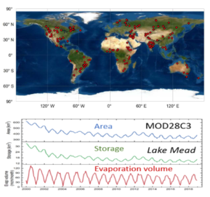
(GWR) Data available at: NASA Interactive Maps: For an interactive interface of the dataset, please see https://landweb.modaps.eosdis.nasa.gov/lake Shah, Deep, Shuai Zhang, Sudipta Sarkar, Carol Davidson, Rui Zhang, Maosheng Zhao, Sadashiva Devadiga, Praveen Noojipady, Miguel O. Román, and Huilin Gao. “Transitioning from MODIS to VIIRS Global Water Reservoir Product.” Scientific Data 11, no. 1 (2024): 209. https://doi.org/10.1038/s41597-024-03028-2
Data description: This product provides area, elevation, storage, evaporation rate, and evaporation volume data for 164 global reservoirs.
Related publication: Li, Yao, Gang Zhao, Deep Shah, Maosheng Zhao, Sudipta Sarkar, Sadashiva Devadiga, Bingjie Zhao, Shuai Zhang, and Huilin Gao. “NASA’s Modis/Viirs Global Water Reservoir Product Suite from Moderate Resolution Remote Sensing Data.” Remote Sensing 13, no. 4 (2021): 565. https://doi.org/10.3390/rs13040565
(GLEV) Data available at: GLEV Dataset Interactive Maps: For an interactive interface of the dataset (Google Earth Engine App), please see https://zeternity.users.earthengine.app/view/glev
Data description: The processed global lake evaporation volume (GLEV) dataset contains monthly lake open areas, evaporation rates, and evaporative water loss data for 1.42 million lakes.
Related publication: Zhao, G., Li, Y., Zhou, L., Gao, H. (2022) Evaporative water loss of 1.42 million global lakes. Nature Communications. https://doi.org/10.1038/s41467-022-31125-6.
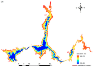
(GRBD) Data available at: Texas Data Repository
Data description: This dataset contains the high resolution 3D bathymetry of 347 global reservoirs, which represents 50% of the overall global storage capacity. It also provides the Area-Elevation (A-E) and Elevation-Volume (E-V) relationships for these reservoirs.
Related publication: Li, Y., H. Gao, G. Zhao, and K. Tseng, A high-resolution bathymetry dataset for global reservoirs using multi-source satellite imagery and altimetry, Remote Sensing of Environment, Vol. 244, 111831, 2020. doi: 10.1016/j.rse.2020.111831.
(CRED) Data available at: Texas Data Repository
Data description: This dataset contains the monthly evaporation volumes for 721 reservoirs from March 1984 to October 2015 in the Contiguous United States. Along with the volume, monthly evaporation rate and surface area (from GRSAD) are also provided.
Related publication: Zhao, G. and H. Gao, Estimating reservoir evaporation losses for the United States: Fusing remote sensing and modeling approaches, Remote Sensing of Environment,doi.org/10.1016/j.rse.2019.03.015.
(GRSAD) Data available at: Texas Data Repository
Data description: This dataset contains the time series of area values for 6817 global reservoirs (with an integrated capacity of 6099 km3) from 1984 to 2015. It was based on the dataset by Pekel et al. (2016), with the contaminations from clouds, cloud shadows, and terrain shadows corrected automatically.
Related publication: Zhao, G. and H. Gao, Automatic correction of contaminated images for assessment of reservoir surface area dynamics, Geophysical Research Letters, doi.org/10.1029/2018GL078343
(CMIP6-CRED) Data available at: Texas Data Repository
Data description: This dataset contains evaporation rates and losses for 678 major reservoirs (representing nearly 90% of total storage capacity) in the Contiguous United States (CONUS) over historical baseline (1980–2019), near-term (2020–2039), and mid-term (2040–2059) future periods.
Related publication: Zhao, B., Kao, S. C., Zhao, G., Gangrade, S., Rastogi, D., Ashfaq, M., & Gao, H. (2023). Evaluating Enhanced Reservoir Evaporation Losses From CMIP6‐Based Future Projections in the Contiguous United States. Earth’s Future,
doi. org/10.1029/2022EF002961.
Data available at: Texas_Daily Lake Evaporation_API
Data description: This dataset contains daily evaporation rates and volumes for 188 major reservoirs in Texas from 1980 to the present. Additionally, the API also provides reservoir-related information such as daily precipitation and dynamic reservoir area.
Related publication: Zhao, B., Huntington, J. Pearson, C., Zhao, G., Ott, T., …, Gao, H.(2024). Developing a General Daily Lake Evaporation Model and Demonstrating Its Application in the State of Texas. Water Resource Research, doi.org/10.1029/2023WR036181.